
Streamwood ZIP Coverage Explained
USPS identifies 60107 as the normal Streamwood mailing ZIP. Census geography also reports six ZCTAs that intersect the village profile. A ZCTA, or ZIP Code Tabulation Area, approximates ZIP geography for statistics. It is not a USPS assignment and does not mean every address in an intersecting area may use that code. The Streamwood ZIP code directory therefore treats 60107 as primary and the other five codes as boundary overlaps that require an exact-address check.
| ZIP Code | Areas Covered | Post Office | Notes |
|---|---|---|---|
| 60107 | Primary Streamwood mailing area | Verify through USPS | Normal Streamwood postal ZIP |
| 60103 | Bartlett-side ZCTA overlap | Bartlett city label | Intersection does not assign the ZIP to every village address |
| 60120 | Elgin-side ZCTA overlap | Elgin city label | Verify the full street and unit |
| 60133 | Hanover Park edge | Hanover Park city label | Postal city and village can differ |
| 60193 | Schaumburg-side ZCTA overlap | Schaumburg city label | Not proof of a Streamwood municipal location |
| 60194 | Schaumburg-side ZCTA overlap | Schaumburg city label | Exact official boundary was not found |
No official split, realignment year, PO-box-only code or unique institutional ZIP for Streamwood was found in the reviewed USPS, Village, Census or county material. That absence matters. Do not invent a station boundary or treat the intersecting ZCTAs as alternate mailing codes.
Verify a Streamwood ZIP
The USPS ZIP Code Lookup is the authority for delivery assignments. Its By Address mode asks for company, required street address, apartment or suite, city, state and an optional ZIP. By City and State requires those two fields, while Cities by ZIP accepts a ZIP and returns recognized city labels.
| USPS mode | Fields | Best use |
|---|---|---|
| By Address | Street, unit, city, state, optional ZIP | Confirm one deliverable Streamwood address |
| By City and State | City and state | See codes associated with the entered postal city |
| Cities by ZIP | Five-digit ZIP | Check accepted city labels for a known code |
Multiple matches call for a unit or a more exact address. USPS also warns that its result does not prove a person or company occupies the address. Use the postal result as one geography key, then turn to the proper custodian for a resident or parcel question.
Find Streamwood Residents by ZIP
Official local tools do not offer a public list of every resident in one ZIP code. A sound ZIP code directory search moves from postal verification to one known address. The Cook County Property Tax Portal accepts an optional ZIP as part of an address query. CookViewer and the Assessor use a street address, intersection or PIN rather than a ZIP-wide filter. Illinois voter access is person-specific and cannot be turned into a public ZIP roster.
- Enter the full street address and apartment or unit in USPS. Record the standardized city and ZIP.
- Search the Cook County Property Tax Portal with house number, street, unit, city and optional ZIP. Capture the PIN and keep the property address separate from the tax mailing address.
- Open CookViewer with the address or PIN to confirm municipality, township, zoning and the relevant school, park, library and tax districts.
- If the goal is a named person, use only the official record suited to that question. Verify identity with a second source and do not infer a household from a parcel owner.
Once the ZIP has narrowed the geography, the Streamwood street directory gives the address-level record chain. That shift is important because 60107 alone is much too broad to identify a household.
Streamwood ZIP Property Fields
The Cook County Property Tax Portal requires house number, street and city for an address search. Unit helps separate apartments, and ZIP is optional. Instructions say to omit street directions and suffixes. A result may show a five-year billing history, property address, separate mailing address, characteristics, assessed values, exemptions, refunds, recent deeds or liens, and tax-sale status.
The manifest capture shows the official Cook County Assessor property fields used with a Streamwood ZIP code directory search.
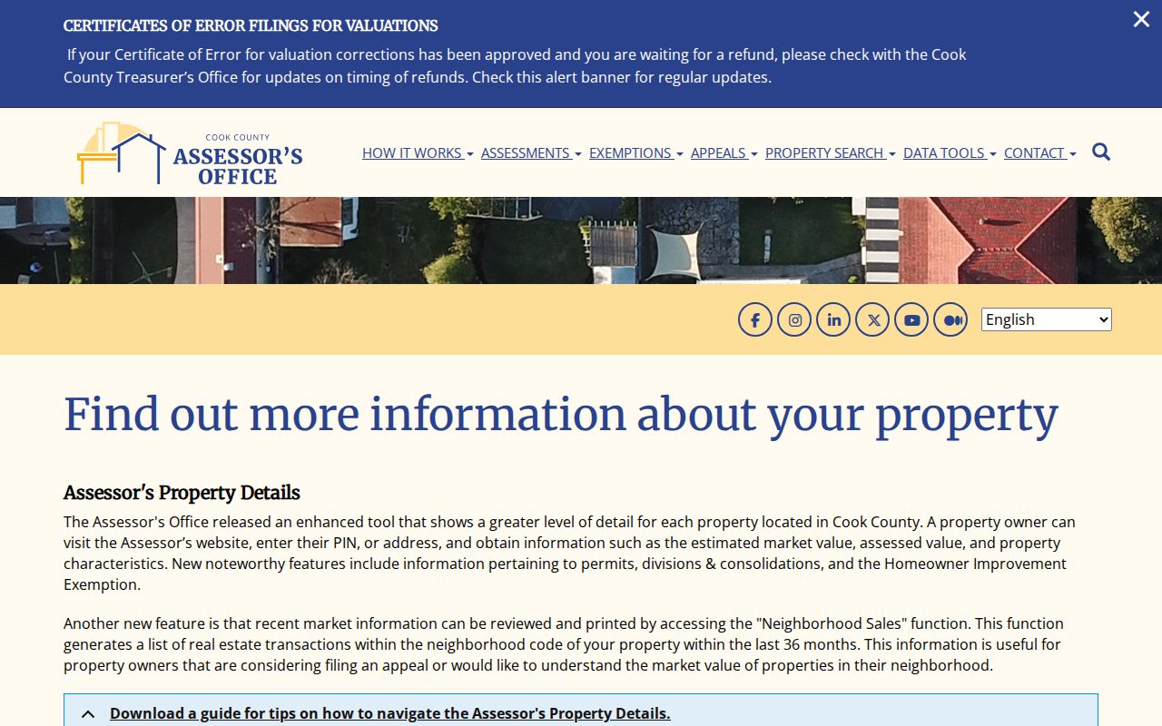
The screen reinforces a core limit: property location, tax mailing address and occupancy are separate facts. A parcel record can support an address match, but it cannot list every person at the site.
For a PIN search, Cook County uses five dashed segments such as 06-13-308-037-0000. The PIN identifies a legal parcel rather than a person or postal route. It often remains the better link when street spelling, municipality labels or ZIP geography changes.
Map Streamwood ZIP Districts
The Streamwood Community Portal takes an address and asks users to include an apartment or unit. It returns local districts, officials and zoning context. CookViewer adds parcel geometry, municipality, township, zoning and political, school, library, park and tax districts. These service boundaries can cross both the ZIP and village line.
Streamwood lies mainly in Hanover Township, about 33 miles northwest of Chicago. Route 59 forms a key western reference, Lake Street marks the south, Irving Park Road divides the village east to west, and Barrington Road runs north to south. These roads help orient a map, but they do not create simple ZIP boundaries.
Boundary check. Compare the USPS delivery result, CookViewer municipality and PIN, recorded legal description, and Village district result. Preserve any mismatch instead of forcing every label to say Streamwood.
Six Streamwood ZCTA Intersections
Census profiles associate Streamwood geography with 60103, 60107, 60120, 60133, 60193 and 60194. This is statistical geography. USPS draws routes for mail delivery, while Census builds ZCTAs from address patterns to publish data. The two systems serve different goals and need not share an exact line.
Use Census figures to understand a broad area, not to locate an individual. The Village's certified 2020 population is 39,577, but a ZCTA statistic cannot say who resides at one Streamwood address. It may also include land outside the village. The same caution applies to per-ZIP totals from private sites.
Note: The exact station-by-station line and any historic Streamwood ZIP realignment year were not verified in official sources.
Older Streamwood ZIP Clues
Streamwood's postal and record context changed with its growth. Before 1957, the area was tied to farms, Hoosier Grove and Hanover Township. Development began with pre-assembled houses in 1956, and the village incorporated in 1957. A historical address search may therefore work better with a township name, farm-road name, subdivision, lot and block than with a modern Streamwood ZIP code.
Boundary disputes with Bartlett and Schaumburg during later growth can explain why deeds, newspapers, maps and postal city labels disagree. Search Bartlett Road, Schaumburg Road, Oltendorf Road, Route 59, Lake Street and Irving Park Road alongside Streamwood and Hanover Township. Confirm each historical result with a dated map, directory, plat or deed.
USPS carrier-route and ZIP+4 data can add delivery precision, but the detailed AIS products are subscription services. For one address, the public USPS lookup remains the practical choice.
Streamwood PIN Versus ZIP
A ZIP code follows mail delivery. A Cook County PIN follows a legal parcel. The PIN is a 14-digit property index number that links assessment, tax, map and recorded-document systems. It may stay useful when a street is spelled in more than one way, a mailing city differs from the village, or an old source predates the current postal label. A condominium unit or common area may also have its own parcel treatment, so never assume that one street address equals one PIN.
Record the legal description when it appears. It may name a subdivision, lot and block, condominium unit, easement, or use metes-and-bounds language. The description controls the land in a recorded instrument. By contrast, the Assessor's property location helps locate the parcel, and the tax portal's mailing block says where correspondence goes. Neither one proves that the named recipient lives there.
A practical reconciliation uses four columns: the address supplied by the searcher, the USPS standardized delivery result, the CookViewer or Assessor property location and PIN, and the deed's legal description. Add the Village district result and tax mailing block when they matter. If one column differs, investigate the unit, boundary, prior road name or municipality. The mismatch is useful evidence, not an error to erase.
Can a ZIP identify one resident? No. It narrows a broad delivery area. A name must still be checked in the official source that fits the question, and a parcel owner must not be treated as a complete household list.
Streamwood ZIP and City Limits
A Streamwood mailing label does not by itself prove that an address lies inside the Village of Streamwood. Cook County, Hanover Township, school districts, park districts, library districts and postal routes have their own boundaries. Near Bartlett, Hanover Park, Schaumburg and Elgin, a postal city or intersecting ZCTA can differ from the municipality shown by CookViewer.
- ZIP and ZIP+4
- A ZIP is the five-digit delivery area. ZIP+4 adds four digits to narrow a delivery segment, building or group of boxes.
- PO-box ZIP
- A code used mainly or only for post-office boxes. No such separate Streamwood code was verified.
- Unique ZIP
- A code assigned to one high-volume organization. No Streamwood example was found in the reviewed sources.
- Carrier route
- A USPS delivery path within a ZIP, not a municipal or parcel boundary.
When the labels conflict, use the source that owns the question. USPS decides delivery. CookViewer and the Assessor identify parcels and mapped jurisdiction. Recorded instruments carry the legal description. The Village determines its zoning and local services. A careful Streamwood ZIP code directory keeps those answers side by side.